Difference between revisions of "Steamly S2-S/Avionics"
(→Radios) |
(→GPS) |
||
| Line 24: | Line 24: | ||
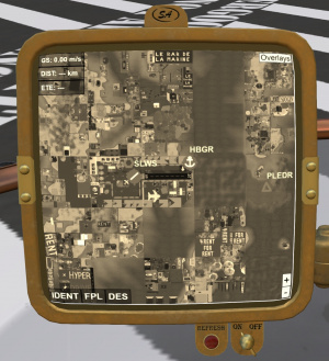
=== GPS === | === GPS === | ||
| + | |||
| + | [[File:S2s-gps.jpg|thumb|right| | ||
| + | <figure id="fig:gps"><caption> | ||
| + | GPS</caption></figure> | ||
| + | ]] | ||
| + | |||
=== Transponder === | === Transponder === | ||
=== ELT === | === ELT === | ||
Revision as of 01:25, 6 May 2022
SECTION 3. AVIONICS
Contents
1 Radios
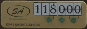
A 760 channel COM radio (Figure 1) is mounted near the bottom of the middle panel. The COM radio operates in the VHF band between 118.000 Mhz and 136.975 Mhz and has a maximum range of about 15 regions (3.75 km). As a station approaches the maximum range, reception quality will begin to degrade.
The selected frequency is shown in the middle of the radio. Three buttons under the displayed frequency cycle through different combinations of digits. In addition the chat commands "com" can be used to select a frequency. For example:
com 128.125
would set the COM frequency to 128.125 MHz.
Each airport in SL, has a specific set of frequencies associated with it that may be viewed by clicking on an airport icon on the Shergood Aviation Map. These frequencies are:
CTAF/TWR - When an airport has an operating control tower, this frequency is used for communication with the control tower. When no control tower is in service, this frequency is the CTAF (Common Traffic Advisory Frequency). The CTAF is used to self-announce position relative to the airport ATIS - Automatic Terminal Information Service - This frequency broadcasts weather and notam information about an airport. Ground - This frequency is used for ground communication at an airport. Normally this frequency is used only when a control tower is in service. In other cases, the CTAF is used. VOR - Frequency of the VOR navigation beacon at an airport. This frequency is used by the NAV radios.

